
Cyclone Arnab is barreling toward India’s eastern seaboard, and the next twenty-four hours could decide how badly Andhra Pradesh, Odisha and West Bengal get battered. A deep depression sitting over the west-central and adjoining northwest Bay of Bengal has intensified rapidly, and meteorologists say it is on the verge of becoming a full-fledged cyclonic storm that would officially be christened Cyclone Arnab. If it strengthens as forecast, this would become the first named cyclone of the 2026 season in the North Indian Ocean, ending a relatively quiet stretch since Cyclone Ditwah tore through Sri Lanka and southern India in November 2025, leaving more than six hundred people dead.
According to the India Meteorological Department, the system was tracked moving west-northwestwards at roughly seven to eighteen kilometres per hour, positioned a few hundred kilometres southeast of Gopalpur in Odisha and east-southeast of Kalingapatnam in Andhra Pradesh. Forecasters expect the weather system, likely to be Cyclone Arnab once formally classified, to cross the coast between Visakhapatnam and Gopalpur sometime between the evening of September 23 and the early hours of September 24, 2026. That narrow landfall corridor places two of India’s most densely populated coastal states directly in the storm’s path, and administrations on both sides of the state border are treating the threat as an emergency-in-waiting rather than a routine monsoon depression.
Why Cyclone Arnab Matters For Millions Along The Coast
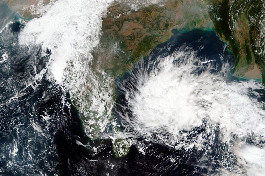
The name itself carries a quiet irony. Arnab means “ocean” in Bengali, and the name was contributed to the World Meteorological Organisation’s regional list by Bangladesh. But there is nothing poetic about what forecasters expect on the ground. The India Meteorological Department has warned of extremely heavy rainfall over Odisha on September 23 and 24, with very heavy showers continuing into September 25 and 26. Coastal Andhra Pradesh is bracing for a similar deluge, with gusty winds and rough sea conditions expected to intensify as the system approaches landfall. Fishermen along both coastlines have been strictly warned to stay off the water until at least September 25, a precaution that reflects how seriously local administrations are treating the developing storm.
Odisha’s state government has already begun rolling out precautionary measures reminiscent of past cyclone responses, including school closures in vulnerable districts and the deployment of emergency response teams to coastal blocks most likely to bear the brunt of Cyclone Arnab’s landfall. Low-lying areas near Ganjam, Gopalpur and neighbouring districts are considered high-risk zones, given their history of flooding whenever a Bay of Bengal system makes landfall nearby. Authorities are also monitoring river levels, since the India Meteorological Department has cautioned that intense rainfall linked to the storm could trigger waterlogging and a rapid rise in water levels across several river basins that have already received significant rain this monsoon season.
West Bengal Also On High Alert As Storm System Advances
While Andhra Pradesh and Odisha sit closest to the projected landfall zone, West Bengal is not being spared either. Rain has already begun falling across several districts of South Bengal, and an orange alert has been issued for East Medinipur, West Medinipur and Jhargram ahead of what forecasters expect to be a wet and windy Thursday. Kolkata itself is expected to see rain accompanied by gusty winds as the outer bands of the system sweep across the region. Further north, Darjeeling, Kalimpong, Jalpaiguri and Alipurduar have all received warnings for heavy to very heavy rainfall over the coming days, a sign of just how wide a footprint this weather system is expected to leave across eastern India.
What makes this particular storm noteworthy is the scale of coordinated tracking across meteorological agencies. Alongside the India Meteorological Department’s own bulletins, global forecasting models including the European Centre for Medium-Range Weather Forecasts and the American Global Forecast System have both signalled the system’s likely intensification, even as they differ somewhat on the exact strength Cyclone Arnab could reach at landfall. That divergence between models is precisely why officials are urging residents to rely strictly on IMD advisories and district administration updates rather than unverified claims circulating on social media about the storm’s supposed severity.
Economic And Human Stakes Of Cyclone Arnab’s Landfall
Cyclones making landfall along this particular stretch of coastline carry outsized economic consequences. The Visakhapatnam-Gopalpur corridor is home to major ports, fishing communities, agricultural belts and industrial infrastructure that have all been battered by previous storms in the same geography, from Cyclone Phalin years ago to Cyclone Gulab more recently. A cyclone of even moderate intensity can disrupt fishing livelihoods for weeks, damage paddy crops nearing harvest, and force temporary shutdowns of port operations along the Andhra Pradesh and Odisha coastlines. Insurance assessors and disaster management officials are already on standby, anticipating claims and relief requirements should the storm intensify beyond current projections.
For residents, the human cost of any cyclone striking this densely populated coast is the paramount concern. Coastal hamlets in Ganjam and Srikakulam districts have seen repeated evacuations over the past decade whenever a Bay of Bengal system approached, and local disaster management authorities say they are following the same playbook this time: pre-positioning relief material, opening cyclone shelters, and coordinating with the National Disaster Response Force and State Disaster Response Force units stationed nearby. Power utilities in both states have also placed repair crews on alert, since gusty winds associated with storms in this category frequently snap power lines and uproot trees across rural stretches.
Meteorologists caution that the exact intensity Cyclone Arnab attains before landfall will depend heavily on sea surface temperatures and wind shear conditions over the next several hours, variables that can shift a system’s strength significantly in a short window. Even so, the consensus across forecasting agencies is that some version of this storm, whether it earns the official cyclone classification or remains a deep depression, will bring a serious and sustained bout of extremely heavy rain, strong winds and rough seas to a coastline that is no stranger to such extremes. Authorities in Andhra Pradesh, Odisha and West Bengal have all activated their respective disaster response protocols, and residents in the projected path have been advised to avoid open areas, isolated trees and exposed electrical infrastructure during thunderstorm activity linked to the system.
As the clock ticks toward the projected landfall window, all eyes remain fixed on the Bay of Bengal, where Cyclone Arnab’s final track and strength will determine just how severe the coming forty-eight hours turn out to be for lakhs of families across India’s eastern seaboard. The India Meteorological Department has promised continuous updates as the system evolves, and coastal residents are being urged, in the strongest possible terms, to heed every evacuation order and marine warning issued in the hours ahead. (Source: Imperium Times)
Whatever its final classification, the storm now widely referred to as Cyclone Arnab has already reshaped daily life across three states, cancelling school days, grounding fishing fleets and putting emergency machinery on a war footing. That, disaster management experts say, is itself evidence of how much has been learned from previous cyclones that struck this same stretch of coast with devastating consequences.
Weather agencies have also flagged the broader climate context behind storms like this one. Warmer than average sea surface temperatures in the Bay of Bengal this season have made rapid intensification more common, a pattern scientists have linked to several destructive systems in recent years. Whether or not Cyclone Arnab reaches severe cyclonic storm strength before it crosses the coast, its formation this week underscores how quickly a routine monsoon depression can escalate into a full-blown coastal emergency, and why early, transparent communication from the India Meteorological Department remains the single most important tool coastal states have for keeping casualties low. Residents planning travel through Andhra Pradesh, Odisha or southern West Bengal over the next three days are being advised to check official bulletins before setting out, as road and rail disruptions are considered likely once Cyclone Arnab makes landfall.
Know more at Imperium Times